You are here
Prioritising Connectivity: Prime Minister Sheikh Hasina’s Visit to India

 Summary: Prime Minister Sheikh Hasina’s visit underlines the fact that India and Bangladesh are successfully leveraging their geographical location to advance mutually beneficial economic ties. Cross-border trade has increased manifold with improvement in connectivity networks. Several challenges though remain, including on aspects relating to coastal shipping, congestion at land ports and deficiencies in cargo-handling capacities.
In the past decade, India–Bangladesh relations have been on an upward swing. The two countries have made strides in bilateral relations as well as on aspects relating to sub-regional cooperation. Cross-border trade has increased manifold with improvement in connectivity networks and infrastructure development funded through India’s nearly US$ 8 billion credit line. India has also established modern Integrated Check Posts (ICPs) in some border crossing points to facilitate trade and people-to-people contact and in others work is continuing in full speed to modernise the existing land custom stations and facilitate fast immigration.
The visit of Prime Minister Sheikh Hasina to India on 5 September 2022 is another manifestation of the high priority bilateral ties have received from the top leadership of the two countries. Critics in Bangladesh have expressed disappointment at the inability of Hasina to get Teesta water sharing treaty signed. Many have also welcomed India’s announcement that Bangladesh can have free transit access to Indian ports for export to third countries. While seven MoUs and agreements were signed during the visit of the Bangladesh PM, this Brief will focus on connectivity aspects and the challenges the two countries are facing to optimise connectivity and trade.
While trade and connectivity issues have received utmost priority in bilateral relations, deficiencies remain. Connectivity infrastructure between the two countries includes rail, road and waterways. Railways is seen as a game-changer in connectivity even though at the moment it is less used. For the past more than a decade, India’s Line of Credit (LoC) is mainly devoted to convert meter gauge railway to broad gauge, building of culverts and bridges over rivers to facilitate seamless rail connectivity. It needs to be emphasised that since the announcement of first line of credit in 2011, effort has been made to restore links that were snapped after the 1965 India–Pakistan War.
Strengthening Transport Connectivity
According to a study by World Bank, “Improving transport connectivity between the two countries could increase exports even further, yielding a 297 percent increase in Bangladesh’s exports to India and a 172 percent increase in India’s exports to Bangladesh”.1 With full transport integration without the border barriers, it is estimated that “income would increase by 16.6 percent in Bangladesh and 7.6 percent in India”.2 This illustrates why connectivity is being prioritised by the two governments not just for bilateral trade by also connecting the Bangladesh–Bhutan–India–Nepal (BBIN) subregion.
Even though it is the most expensive medium of transportation, roadways have remained an important medium of transport. The Chairman of Bangladesh’s Land Port Authority states that “most of the goods travelling from Bangladesh to India move by land, with 70.4 per cent of exports to India having been transported by road or rail”.3
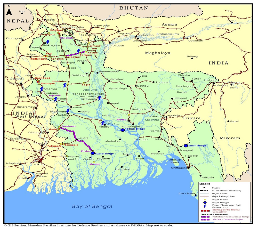
During Prime Minister Hasina’s visit, some steps were taken to further boost the existing rail connectivity. The two countries announced consultancy contract for the much-awaited upgradation of Khulna–Darshana and Parbotipur–Kaunia railway line, which was supposed to be completed in 2018. The Khulna–Darshana project will help enhance connectivity on the Khulna–Dhaka, Khulna–Chilahati, and Khulna–Rajshahi routes, as well as between the Mongla Port and Darsana-Gede on the Indian border (Map 1).4 Parbotipur–Kaunia railway line would strengthen the connectivity between Lalmonirhat and Panchgarh in Bangladesh. This would also be important for sub-regional connectivity as this route connects Birol–Radhikapur route further to Nepal and also to Assam on the eastern side. Due to its importance, this project, which was earlier categorised as ‘low priority’ in Bangladesh, has been upgraded to ‘medium priority’.5
It needs to be noted that 99 per cent of the cargo that is moved by rail constitutes Bangladesh’s imports from India.6 The restored Haldibari–Chilahati rail route, opened after 56 years in August 2021, is expected to see 20 freight trains per week.7 The emphasis on Railway Bridge is evident as the two countries inaugurated Rupsha Rail Bridge, which will connect Khulna with Mongla port for the first time by single-track broad gauge line. This will also connect to Gede and Petrapole on Indian border (Map 1).
Bangladesh has requested India to open this route for exports to Bhutan while India has requested to lift restrictions placed on trade at this border point to optimise this connectivity. Map 1 shows the existing rail connectivity and how these lines connect to major border points with India. The power stations are marked in the map to show how these routes can be used to supply raw material to these power plants.
The Maitri Bridge over Feni can be used to transport cargos from the North East to Chittagong port which is 80 kms away from Sabroom. This will improve connectivity of south Assam, Mizoram and Manipur along with Tripura with Bangladesh and further to South-East Asia.8 Prime Minister Hasina, while inaugurating this bridge, emphasised its bilateral and sub-regional significance. She added that “political boundaries should not become physical barriers for trade. It (the bridge) will also help Bangladesh’s trade with Nepal and Bhutan”.9
Map 1 shows the railway connectivity network in Bangladesh and India and it also shows the potential of sub-regional connectivity as these lines connect to Nepal and Bhutan via India. The new lines that were announced during this visit are highlighted in purple on the map.
Trading through Waterways
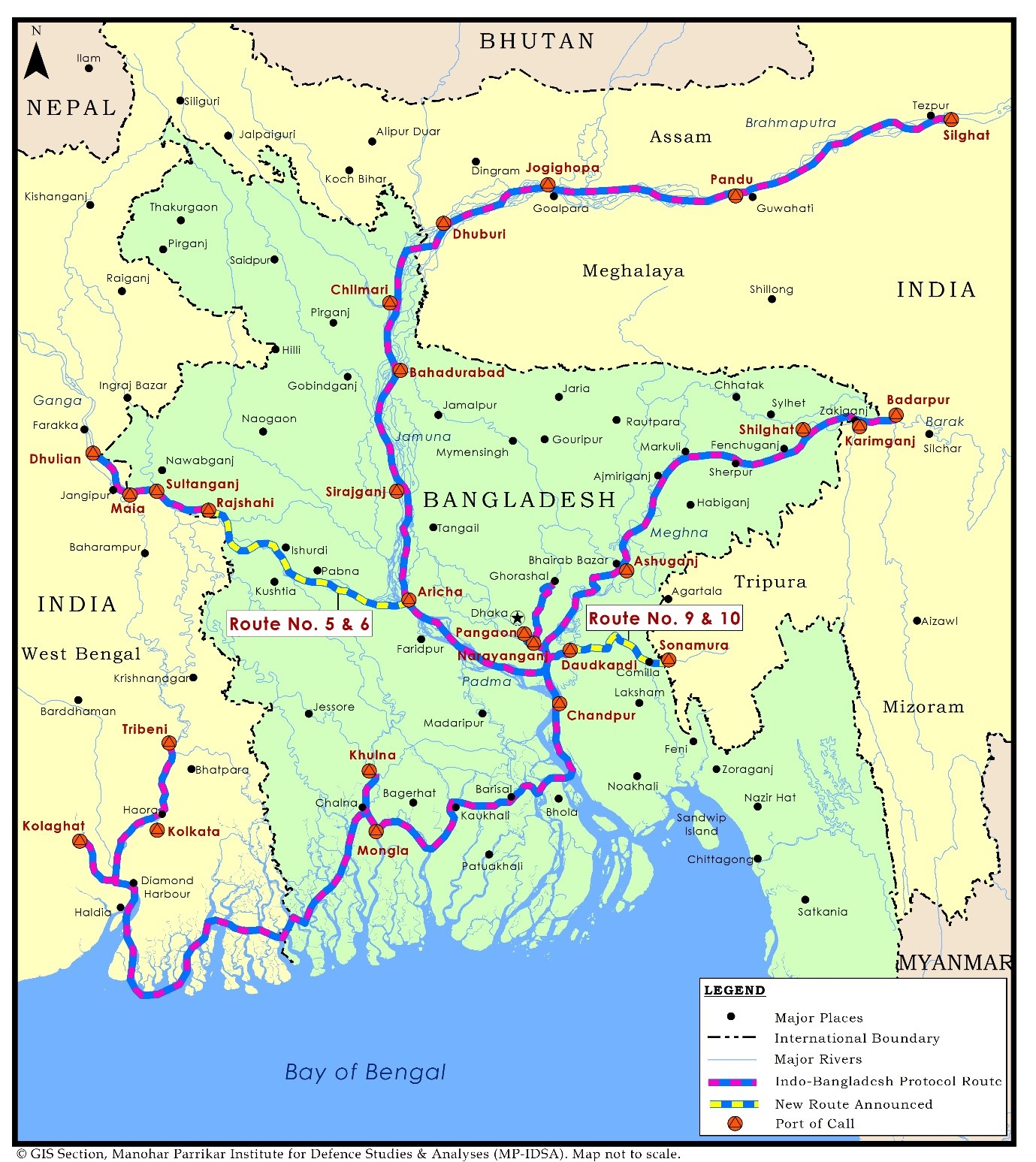
Trade by the 3,500 kms of waterways remains the cheapest mode of connectivity between the two countries. Yet, navigability remains a major challenge during summer as only smaller vessels with small draft can move on this route. After India decided to connect Waterway 1 and Waterway 2 to the India–Bangladesh Protocol Route (IBPR), two more routes were added to the eight functioning routes in the additional addendum to the IBPR of 1972.10
In 2019, after India opened up National Waterway, Bhutan used Dhubri to transport stones to Bangladesh’s Narayanganj which takes only six days, saving on transportation costs as well as time. In March 2022, the Waterways 1 and 2 were connected facilitating transport across Ganga and Brahmaputra—the two major rivers that India and Bangladesh share.11 During this visit, it was announced that Routes 5 and 6 will be connected. This will reduce the distance between Waterway 1 and Waterway 2 by 1,000 kms12 (see Map 2), and connect North East of India through Bangladesh and further to India (see Map 3).
Inclusion of Jogigopha, where a multimodal logistic park is being proposed, would help in better connectivity to Meghalaya, Assam and Bhutan. This was a long-standing demand as stones from Bhutan can be transported through this route instead of Dhubri. The Ministry of Shipping in India now allows shallow draft mechanised vessels for this purpose. Goods from Assam can now reach Tripura through the newly announced route of Dhoudkhadi and Sonamura (see Map 3; new route is marked in the map) and from Aricha it can reach Dhulian in West Bengal depending on the destination of cargo.

This also indicates that though the waterways is cheaper, draft of a boat and depth of the river determines a vessel’s navigability. Not surprisingly, there is overwhelming dependence on road and rail as ports are not very well-connected to the existing rail and road infrastructure.
Boosting Trade through Land Ports
Infrastructure in Land Port Authority also needs immediate attention. Though Petrapole land port on the Indian side has been modernised, Benapole requires attention. Under the World Bank Bangladesh Regional Connectivity Project (Phase-1), infrastructure in three land ports of Bangladesh—Ramgarh, Sheola and Benapole—is being developed and Bhomra, Burimari, and Bholaganj are under consideration.13
Though Benapole remains the largest trading point between India and Bangladesh, congestion remains a major issue. It is important to have four-lane road that connects Benapole. Construction of second cargo gate to some extent will help in faster clearance of cargoes. Comparatively, Agartala–Akhaura has better facilities as it is connected to NH 8 through arterial road. It is the second largest land port. Transit trade is greatly challenged by highway infrastructure in each of the country. According to the World Bank, transport vehicles within Bangladesh have “an average speed of 19 kilometers an hour along main corridors”, indicating that the roads are congested.
It is important to note that Bangladesh’s import of raw material from India has helped its domestic readymade garment industry to grow. It has boosted its export of readymade garments to markets in the West. Therefore, many in Bangladesh argue that the country should not get bogged down with its trade balance with India. These are primary goods that Bangladesh requires to profit elsewhere. India remains Bangladesh’s second largest trading partner after China. India is the seventh largest export destination of Bangladesh whereas China does not even figure in the top 11 export destinations listed by Bangladesh (Table 1).
Table 1: Total imports as percentage of total trade of Bangladesh
|
|
China |
India |
||
|
|
Import |
Export |
Import |
Export |
|
2019-2020 |
20.64% |
- |
12.07 |
3.51% |
|
2020-2021 |
20.36 |
- |
15.98 |
3.29 |
Source: Foreign Trade Statistics of Bangladesh 2020-21, Bangladesh Bureau of Statistics, Statistics and Informatics Division, Ministry of Planning, Government of the People’s Republic of Bangladesh, May 2022, p. xiv (import), p. xxx (for export).
Bangladesh remains India’s largest trade destination in the region. Since 2009, bilateral trade which stood at US$ 2 billion has now touched nearly US$ 19 billion. Bangladesh accounts for 47.2 per cent of India’s total exports to the region, and 36 per cent of India’s total imports from the region in 2021.14 With the removal of existing non-tariff trade barriers, it is likely to grow further. There are several roadblocks, including the time taken for clearance of cargo vehicles. During Hasina’s visit, India requested Bangladesh to have ‘one major land port without port restrictions or negative list restrictions, on the border with North Eastern States of India, for easier market access, starting with ICP Agartala–Akhaura’.15
According to a report, a cargo truck takes 138 hours to move across the border from India to Bangladesh, and requires 22 documents and 55 signatures.16 From Benapole on Bangladesh side to Petrapole on Indian side, it takes about 120 hrs.17 A World Bank study states that Bangladesh’s Benapole border point can only clear up to 370 trucks while India’s Petrapole border can handle up to 750 trucks a day.18 Capacity on the Bangladesh side is almost half of the existing capacity on the Indian side. According to a study by the National Board of Revenue (NBR), Bangladesh, the movement of cargoes and passengers has increased, for instance, ‘from about 87,000 in fiscal year (FY) 2013 to more than 1,08,000 in FY21’, however, the capacity of the land port remains the same. Besides cargo-loaded trucks, the port also manages about 8,000 passengers per day.19 A 24/7 customs clearance has also been introduced but that has not helped the matter much as trade has also increased.
However, in spite of India having comparatively better clearance facility to optimise cross-border trade, Petrapole requires complete overhaul of road infrastructure. There is congestion on the road leading to this border point. According to the Asian Development Bank (ADB), “Mismatch in parking facility with limited clearance of Indian cargo on Bangladeshi side leads to significant waiting period for cargo vehicles, and results in: (i) traffic congestion in Bongaon and (ii) detention and parking charges for exporters”.20
Over a period of time, a local nexus has emerged which is making profits from this non-tariff barrier, including those who own private parking space. Even though India has tried to decongest the parking by levying hefty penalty after 24 hours, this has benefitted the private parking owners. At present, it has the capacity to park 2,000 vehicles. India is ranked 63rd21 in the ‘Trading Across Borders’ category of the World Bank’s Doing Business 2020 report whereas Bangladesh ranks 168 out of 190 countries.22 Bangladesh’s five-year plan has a provision for spending 2 per cent of its GDP on power, energy and infrastructure sectors. It also plans to spend 1–1.5 per cent of its GDP on financing infrastructure which would be mobilised through public–private partnership (PPP) funding.23
Table 2: Exports and Imports in Selected Land Ports (in Million Metric Tonnes)
|
|
2015-16 |
2016-17 |
2017-18 |
2018-19 |
2019-2020 |
|||||
|
Name of the Port |
import |
export |
import |
export |
import |
export |
import |
export |
import |
export |
|
Benapole |
1.2 |
.47 |
1.3 |
.32 |
1.9 |
(.35) |
2.1 |
.40 |
2.03 |
.31 |
|
Sonamasjid |
1.6 |
------ |
2.7 |
.025 |
2.6 |
(.012) |
2.3 |
(.015) |
1.3 |
.012 |
|
Hilli |
.84 |
.006 |
2.4 |
.004 |
1.6 |
.016 |
1.3 |
.037 |
1.8 |
.022 |
|
Akhaura |
11 |
568480 |
2 |
214,955 |
60 |
201580 |
66 |
209962 |
67 |
141881 |
|
Bibir Bazar |
231 |
108915 |
455 |
135320 |
317 |
158331 |
479 |
170458 |
354 |
133870 |
|
Banglabandh |
935486 |
.031 |
0.6 |
7051 |
1207323 |
69205 |
1796869 |
42632 |
1186058 |
113390 |
|
Bhomra |
1816930 |
91109 |
2254764 |
127430 |
4656415 |
119510 |
2201557 |
311771 |
2516070 |
206328 |
|
Nakugaon |
.042 |
---- |
.12 |
33trucks |
.009 |
.0007 |
.065 |
.0013 |
.085 |
.0006 |
|
Tamabil |
|
|
|
|
.78 |
.001 |
1.8 |
.001 |
1.4 |
.0006 |
|
Sonahaat |
|
|
|
|
|
|
.13 |
.0001 |
.20 |
.005 |
Note: Burimari is excluded from the table as numbers are given in terms of truckload than volume in metric tonnes. In 2016–17, there were only 33 truckloads of trade in Nakugaon land port.
Source: Export and Import data of the Bangladesh Land Port Authority Controlled Land ports.
During this visit, the two countries took a decision to discuss Comprehensive Economic Partnership Agreement (CEPA) to facilitate trade after Bangladesh loses out on concession that it is enjoying as a ‘Least Developed Country’ when it will graduate to becoming a ‘Developing Country’ in 2026. Moreover, it is important that trade in service is introduced, which is an important component to move towards regional market integration.
Challenges to Connectivity
There are several challenges to connectivity between India and Bangladesh. Many of the projects that are being implemented under the Indian Line of Credit are being monitored by the Foreign Ministers of the two countries who chair the Joint Coordination Committee (JCC). There are several challenges involving coastal shipping, for instance. The former MD of Coastal Shipping stated that “Often, first and last-mile connectivity is more expensive than coastal freight making the entire cost of logistics very high”.24
This is very much evident from the fact that the handling capacity of both Bangladesh and India in the Benapole–Petrapole border is different. Parking mafias that operate in the border area benefit from the delay in clearing of the customs for loading and unloading of cargoes.25 Moreover not just Benapole able to clear few cargo trucks but Bangladesh also prioritises clearance of containerised cargo of cotton fabric and truck chassis.26 To maintain the protocol routes as dredging is required in some places, India paid 1,000 lakh BD taka (US dollar in convertible currency) for the period 1 April 2015 to 31 March 2016.27 This can be enhanced as the cost goes up. At present, eight bunkering facilities are available in each of the countries. While all these are important steps to maximise the use of waterways, these should have good onward connectivity to road and rail tracks.
India has already connected Waterways 1 and 2 and this will significantly improve sub-regional connectivity between Bangladesh, Bhutan, India and Nepal. The trade and infrastructure connectivity will get boost with cross-border electricity trade as grids get connected to each other. India has announced guidelines for cross-border electricity trade that would help private entities to engage in trade.28 Countries of the region can think of joining Indian Energy Exchange which is engaged in cross-border energy trade.29
Conclusion
India–Bangladesh relations have traversed a long distance. Bilateral trade has grown in tandem with improvement in connectivity infrastructure. There is robust cooperation in energy, infrastructure, border management and defence. Hasina’s visit underlines the fact that India and Bangladesh are successfully leveraging their geographical location to advance mutually beneficial economic ties.
Views expressed are of the author and do not necessarily reflect the views of the Manohar Parrrikar IDSA or of the Government of India.
- 1. Matías Herrera Dappe and Charles Kunaka, eds, Connecting to Thrive: Challenges and Opportunities of Transport Integration in Eastern South Asia, World Bank, 2021, p. 4.
- 2. Ibid.
- 3. Md. Alamgir, “Land Ports in Connectivity, Trade, Growth”, New Age, 14 June 2022.
- 4. “India and Bangladesh Partner on Two Rail Projects”, Railway Technology, 26 August 2022.
- 5. Tuhin S. Adhikari, “Khulna-Darshana Double Rail Track: Half of Project Period Gone for Nothing”, The Daily Star, 23 September 2020.
- 6. “Delegation of Journalists from Bangladesh Calls on Railway Minister”, Press Information Bureau, Ministry of Railways, Government of India, 18 September 2013.
- 7. “Starting of Freight Trains via Restored Haldibari (India) – Chilahati (Bangladesh) Rail Link”, Press Information Bureau, Ministry of Railways, Government of India, 2 August 2021.
- 8. Ibid.; “PM Inaugurates ‘Maitri Setu’ between India and Bangladesh”, Press Information Bureau, Prime Minister’s Office, Government of India, 9 March 2021.
- 9. “Political Boundaries Should Not Become Physical Barriers for Trade: Bangladesh PM Sheikh Hasina”, Financial Express, 9 March 2021.
- 10. Around 638 inland vessels (including 600 Bangladeshi flag vessels) completed approximately 4,000 loaded voyages annually. Presently there are six Ports of Call each in India and Bangladesh under the Protocol. Five more Ports of Call and two more extended Ports of Call have been added, increasing the number to 11 Ports of Call and two extended Ports of Call in each country. See “Second Addendum on Protocol on Inland Water Transit and Trade between India and Bangladesh, 2020”, Press Information Bureau, Ministry of Port, Shipping and Waterways, Government of India, 20 May 2020.
- 11. To improve the navigability, two stretches of IBP routes, i.e., Sirajganj–Daikhowa and Ashuganj–Zakiganj are also being developed at a cost of Rs 305.84 crore on an 80:20 share basis (80 per cent being borne by India and 20 per cent by Bangladesh).
- 12. Subhash Narayan, “Brahmaputra G Connected with Ganga via Indo Bangladesh Protocol Route”, Mint, 6 March 2022.
- 13. “Bangladesh Constructing 7 New Land Ports”, South Asia Subregional Economic Cooperation (SASEC), 26 August 2021.
- 14. Figures are for 2021–22 Financial Year. See “Yearly Export-Import Data Bank”, Ministry of Commerce, Government of India.
- 15. “India-Bangladesh Joint Statement during the State Visit of Prime Minister of Bangladesh to India”, Ministry of External Affairs, Government of India, 7 September 2022, point no. 22.
- 16. Nayanima Basu, “It takes 138 hrs, 55 signatures to move 1 truck from India to Bangladesh, says World Bank”, The Print, 29 April 2022.
- 17. Time Release Study 2022, National Board of Revenue, Government of Bangladesh, p. 7.
- 18. Mandakini Kaul, “A Visit to India’s Busiest Integrated Border Crossing Shows Need for Regional Cooperation and Connectivity”, World Bank, 10 February 2022.
- 19. Time Release Study 2022, no. 17.
- 20. “Strengthening Trade Along the Dhaka–Kolkata Route for a Prosperous and Integrated South Asia”, Asian Development Bank, December 2021, p. 15.
- 21. Doing Business 2020–Comparing Business Regulation in 190 Economies, World Bank, 2020 , p. 8.
- 22. “Strengthening Trade Along the Dhaka–Kolkata Route for a Prosperous and Integrated South Asia”, no. 20, p. 7.
- 23. 8th Five Year Plan, 2020-2025, General Economics Division, Bangladesh Planning Commission, p. 119.
- 24. “Coastal Shipping: Dragging Along Perennial Issues—H.K. Joshi, Former CMD, Shipping Corporation of India”, Maritime Gateway, July–September 2022, p. 13.
- 25. Author’s interview with Bangladesh traders in Sonamasjid border crossing where I participated in India-Bangladesh traders meeting organised in the border by Bangladeshi traders. 22 December 2018. The situation has not changed even now.
- 26. Pratim Ranjan Basu, “24X7 Customs Clearing Fails to Boost Trade at Petrapole”, Business Line, 6 December 2021.
- 27. “Protocol on Inland Water Transit and Trade”, Ministry of External Affairs, Government of India.
- 28. India has introduced guidelines in 2019, revised in 2020 and further clarified in 2021 for cross-border electricity trade.
- 29. IEX has pioneered cross-border electricity trade expanding its power market beyond India in an endeavour to create an integrated South Asian Power Market. IEX is powered by state-of-the-art, intuitive and customer-centric technology, enabling efficient price discovery and facilitating the ease of power procurement. IEX has a robust ecosystem of 6,800+ participants located across 29 States and five Union Territories comprising of 55+ distribution utilities and 500+ conventional generators. See “Overview”, Indian Energy Exchange.